Category:Asia/Philippines/Zambales/Subic Bay Freeport Zone/: Difference between revisions
No edit summary |
|||
| (9 intermediate revisions by 4 users not shown) | |||
| Line 2: | Line 2: | ||
{{Coord|14|48|23|N|120|17|30|E|display=title}} | {{Coord|14|48|23|N|120|17|30|E|display=title}} | ||
* Overview | * Overview | ||
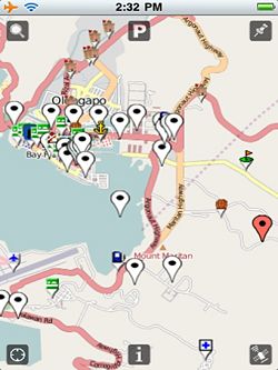
[[Image:Tomacruz-2009-09-03-14-32-29.jpg|right|250px|thumb|Navigate SBFZ using your Iphone with [[Wikimap]]]] | |||
Subic Bay Freeport Zone is located southwest of the Luzon Island in the Philippines. The harbor is sandwiched by the Zambales Mountain Range at the east and the Subic Bay at the west and opens up to the South China Sea. It is northwest of the Bataan Peninsula and southwest of the Zambales Province. SBF is 110 kilometers north of Manila. Manila Bay and the Bataan Peninsula separate SBF from Manila. The mountain ranges around the Subic Bay area and the deep natural harbor provide excellent and protected anchorage. In addition, these features make SBF naturally sheltered from typhoons as well as from the effects of the eruption of Mt. Pinatubo. <ref name=travelsmart>[http://www.travelsmart.net/ph/resorts/Subic/ Subic] TravelSmart.NET. Accessed November 2007.</ref> | Subic Bay Freeport Zone is located southwest of the Luzon Island in the Philippines. The harbor is sandwiched by the Zambales Mountain Range at the east and the Subic Bay at the west and opens up to the South China Sea. It is northwest of the Bataan Peninsula and southwest of the Zambales Province. SBF is 110 kilometers north of Manila. Manila Bay and the Bataan Peninsula separate SBF from Manila. The mountain ranges around the Subic Bay area and the deep natural harbor provide excellent and protected anchorage. In addition, these features make SBF naturally sheltered from typhoons as well as from the effects of the eruption of Mt. Pinatubo. <ref name=travelsmart>[http://www.travelsmart.net/ph/resorts/Subic/ Subic] TravelSmart.NET. Accessed November 2007.</ref> | ||
* Webcam: [http://www.mycam-asia.tv/cams/philippines/luzon/broadwater_subic/display_featured_hour.php] | |||
== Gallery == | |||
== | |||
<gallery> | |||
Image:Grace-2009-12-07-03-52-56.jpg| | |||
Image:Grace-2009-12-07-03-53-32.jpg|JEST (Jungle Environmental Survival Training) Camp | |||
Image:Grace-2009-12-07-03-54-50.jpg|Subic Bay Ocean Adventure | |||
Image:Grace-2009-12-07-03-55-39.jpg|Zoobic Safari | |||
</gallery> | |||
== | == Articles == | ||
* [http://www.travelsmart.net/article/10000569/ Heaven in Subic] | |||
* [http://www.travelsmart.net/article/10000647/ The Terrain of Subic] | |||
* [https://time-calculator.io/ time calculator] | |||
[[Category:Asia/Philippines/Zambales/]] | |||
== Related Links == | == Related Links == | ||
Latest revision as of 07:22, 24 April 2024
Subic Bay Freeport Zone
- Overview

Subic Bay Freeport Zone is located southwest of the Luzon Island in the Philippines. The harbor is sandwiched by the Zambales Mountain Range at the east and the Subic Bay at the west and opens up to the South China Sea. It is northwest of the Bataan Peninsula and southwest of the Zambales Province. SBF is 110 kilometers north of Manila. Manila Bay and the Bataan Peninsula separate SBF from Manila. The mountain ranges around the Subic Bay area and the deep natural harbor provide excellent and protected anchorage. In addition, these features make SBF naturally sheltered from typhoons as well as from the effects of the eruption of Mt. Pinatubo. [1]
- Webcam: [1]
Gallery
-
-
JEST (Jungle Environmental Survival Training) Camp
-
Subic Bay Ocean Adventure
-
Zoobic Safari
Articles
Related Links
References
Subcategories
This category has the following 2 subcategories, out of 2 total.
Pages in category "Asia/Philippines/Zambales/Subic Bay Freeport Zone/"
The following 92 pages are in this category, out of 92 total.
A
- Asia/Philippines/Zambales/Subic Bay Freeport Zone/88 Mart/
- Asia/Philippines/Zambales/Subic Bay Freeport Zone/Alava Pier/
- Asia/Philippines/Zambales/Subic Bay Freeport Zone/All Hands Beach/
- Asia/Philippines/Zambales/Subic Bay Freeport Zone/American Hardware/
- Asia/Philippines/Zambales/Subic Bay Freeport Zone/Apaliin Forest Trail/
- Asia/Philippines/Zambales/Subic Bay Freeport Zone/Apec Villas/
- Asia/Philippines/Zambales/Subic Bay Freeport Zone/Aresi's Restaurant-Bar/
- Asia/Philippines/Zambales/Subic Bay Freeport Zone/Bank of the Philippine Islands/
- Asia/Philippines/Zambales/Subic Bay Freeport Zone/Brent International School Subic/
- Asia/Philippines/Zambales/Subic Bay Freeport Zone/Camayan Wharf/
- Asia/Philippines/Zambales/Subic Bay Freeport Zone/Court Meridian Hotel/
- Asia/Philippines/Zambales/Subic Bay Freeport Zone/Dungaree Beach/
- Asia/Philippines/Zambales/Subic Bay Freeport Zone/Duty Free Superstore/
- Asia/Philippines/Zambales/Subic Bay Freeport Zone/Edgewater/
- Asia/Philippines/Zambales/Subic Bay Freeport Zone/Extreme Adventure Park/
- Asia/Philippines/Zambales/Subic Bay Freeport Zone/Fedex/
- Asia/Philippines/Zambales/Subic Bay Freeport Zone/Fishing/
- Asia/Philippines/Zambales/Subic Bay Freeport Zone/Forest Hills Village Resort/
- Asia/Philippines/Zambales/Subic Bay Freeport Zone/Forest View Leisure Residences/
- Asia/Philippines/Zambales/Subic Bay Freeport Zone/Freeport Gas Station/
- Asia/Philippines/Zambales/Subic Bay Freeport Zone/Gerry's Grill/
- Asia/Philippines/Zambales/Subic Bay Freeport Zone/Gerry's/
- Asia/Philippines/Zambales/Subic Bay Freeport Zone/Grand Seasons Hotel/
- Asia/Philippines/Zambales/Subic Bay Freeport Zone/Grande Island Resort/
- Asia/Philippines/Zambales/Subic Bay Freeport Zone/Grande Island/
- Asia/Philippines/Zambales/Subic Bay Freeport Zone/Hanjin - Phil/
- Asia/Philippines/Zambales/Subic Bay Freeport Zone/Harbor Point/
- Asia/Philippines/Zambales/Subic Bay Freeport Zone/Hotel Inter Park/
- Asia/Philippines/Zambales/Subic Bay Freeport Zone/Jest Camp/
- Asia/Philippines/Zambales/Subic Bay Freeport Zone/Kalaklan Gate/
- Asia/Philippines/Zambales/Subic Bay Freeport Zone/Kalayaan Gate/
- Asia/Philippines/Zambales/Subic Bay Freeport Zone/Le Mans Go Kart/
- Asia/Philippines/Zambales/Subic Bay Freeport Zone/Legenda Hotel/
- Asia/Philippines/Zambales/Subic Bay Freeport Zone/Legenda Suites/
- Asia/Philippines/Zambales/Subic Bay Freeport Zone/Leyte Pier/
- Asia/Philippines/Zambales/Subic Bay Freeport Zone/Lyceum Subic Bay/
- Asia/Philippines/Zambales/Subic Bay Freeport Zone/Main Gate/
- Asia/Philippines/Zambales/Subic Bay Freeport Zone/Mango Valley Business Suites/
- Asia/Philippines/Zambales/Subic Bay Freeport Zone/Meat Plus Cafe/
- Asia/Philippines/Zambales/Subic Bay Freeport Zone/Morong Gate/
- Asia/Philippines/Zambales/Subic Bay Freeport Zone/Mountain Woods Resort/
- Asia/Philippines/Zambales/Subic Bay Freeport Zone/National Bookstore/
- Asia/Philippines/Zambales/Subic Bay Freeport Zone/Networx Jetsports/
- Asia/Philippines/Zambales/Subic Bay Freeport Zone/Ocean Adventure/
- Asia/Philippines/Zambales/Subic Bay Freeport Zone/Oriental Paradise Casino/
- Asia/Philippines/Zambales/Subic Bay Freeport Zone/Pamulaklakin Forest Trail/
- Asia/Philippines/Zambales/Subic Bay Freeport Zone/Pancake House/
- Asia/Philippines/Zambales/Subic Bay Freeport Zone/Petron/
- Asia/Philippines/Zambales/Subic Bay Freeport Zone/Pier One Bar and Grill/
- Asia/Philippines/Zambales/Subic Bay Freeport Zone/PTT Gas Station/
- Asia/Philippines/Zambales/Subic Bay Freeport Zone/Rizal Gate/
- Asia/Philippines/Zambales/Subic Bay Freeport Zone/RK Hotel/
- Asia/Philippines/Zambales/Subic Bay Freeport Zone/Royal Subic Mall/
- Asia/Philippines/Zambales/Subic Bay Freeport Zone/San Roque Chapel/
- Asia/Philippines/Zambales/Subic Bay Freeport Zone/Sbma entrance/
- Asia/Philippines/Zambales/Subic Bay Freeport Zone/Sbma toll/
- Asia/Philippines/Zambales/Subic Bay Freeport Zone/SCTEX Tipo Interchange/
- Asia/Philippines/Zambales/Subic Bay Freeport Zone/Segara Villas/
- Asia/Philippines/Zambales/Subic Bay Freeport Zone/Signature Brands Lifestyle Factory Outlet/
- Asia/Philippines/Zambales/Subic Bay Freeport Zone/Spanish Gate/
- Asia/Philippines/Zambales/Subic Bay Freeport Zone/Starbucks Coffee/
- Asia/Philippines/Zambales/Subic Bay Freeport Zone/Subic Bay Equestrian Center/
- Asia/Philippines/Zambales/Subic Bay Freeport Zone/Subic Bay Golf and Country Club/
- Asia/Philippines/Zambales/Subic Bay Freeport Zone/Subic Bay International Airport/
- Asia/Philippines/Zambales/Subic Bay Freeport Zone/Subic Bay International Tennis Center/
- Asia/Philippines/Zambales/Subic Bay Freeport Zone/Subic Bay Medical Center/
- Asia/Philippines/Zambales/Subic Bay Freeport Zone/Subic Bay Metropolitan Authority/
- Asia/Philippines/Zambales/Subic Bay Freeport Zone/Subic Bay Yacht Club/
- Asia/Philippines/Zambales/Subic Bay Freeport Zone/Subic Boardwalk Inn/
- Asia/Philippines/Zambales/Subic Bay Freeport Zone/Subic Family Land Nature Adventure Park/
- Asia/Philippines/Zambales/Subic Bay Freeport Zone/Subic Holiday Villas/
- Asia/Philippines/Zambales/Subic Bay Freeport Zone/Subic Homes Resort/
- Asia/Philippines/Zambales/Subic Bay Freeport Zone/Subic International Raceway/
- Asia/Philippines/Zambales/Subic Bay Freeport Zone/Subic Park Hotel/
- Asia/Philippines/Zambales/Subic Bay Freeport Zone/Subic Power Corporation/
- Asia/Philippines/Zambales/Subic Bay Freeport Zone/Subic Scuba College/
- Asia/Philippines/Zambales/Subic Bay Freeport Zone/Subic Technopark/
- Asia/Philippines/Zambales/Subic Bay Freeport Zone/Tappan Park/
- Asia/Philippines/Zambales/Subic Bay Freeport Zone/The Aristocrat Restaurant/
- Asia/Philippines/Zambales/Subic Bay Freeport Zone/The Lighthouse Marina Resort/
- Asia/Philippines/Zambales/Subic Bay Freeport Zone/Times Square Plaza/
- Asia/Philippines/Zambales/Subic Bay Freeport Zone/Total/
- Asia/Philippines/Zambales/Subic Bay Freeport Zone/Tree Top Adventure Subic/
- Asia/Philippines/Zambales/Subic Bay Freeport Zone/Triboa Bay Country Club/
- Asia/Philippines/Zambales/Subic Bay Freeport Zone/Triboa Mangrove Park/
- Asia/Philippines/Zambales/Subic Bay Freeport Zone/Vista Marina Hotel and Resort/
- Asia/Philippines/Zambales/Subic Bay Freeport Zone/Watercraft Ventures/
- Asia/Philippines/Zambales/Subic Bay Freeport Zone/Winstron/
- Asia/Philippines/Zambales/Subic Bay Freeport Zone/Xtremely Xpresso Cafe/
- Asia/Philippines/Zambales/Subic Bay Freeport Zone/Yellow Cab Pizza/
- Asia/Philippines/Zambales/Subic Bay Freeport Zone/Yokohama/
- Asia/Philippines/Zambales/Subic Bay Freeport Zone/Zoobic Safari/


