Asia/Philippines/Leyte/Tacloban City/San Juanico Bridge/: Difference between revisions
No edit summary |
No edit summary |
||
| (One intermediate revision by the same user not shown) | |||
| Line 13: | Line 13: | ||
<gallery> | <gallery> | ||
Image:Tomacruz-2009-10-03-10-03-02.JPG| | Image:Tomacruz-2009-10-03-10-03-02.JPG| | ||
Image:Tomacruz-2009-10-03-10-04-48.JPG| | |||
Image:Tomacruz-2009-10-03-10-05-59.JPG| | |||
</gallery> | </gallery> | ||
[[Category:Asia/Philippines/Leyte/Tacloban_City/]] | [[Category:Asia/Philippines/Leyte/Tacloban_City/]] | ||
Latest revision as of 10:05, 3 October 2009
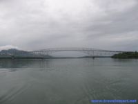
San Juanico Bridge

- Crossing over San Juanico Strait, connects Brgy. Cabalawan, Tacloban City (Leyte side) and Sta. Rita town (Samar side), approximately 10 minutes from Tacloban City; accessible by passenger jeepneys, buses, motorcabs and private vehicles. Longest and most beautifully designed bridge in the Philippines; picturesque San Juanico Strait with a thousand whirlpools; lovely islets; picturesque views.
Articles
- 18-day drive to see Leyte landing rites
- Cruising cross-country Day Three: Sightseeing in Tacloban ...
- Dabong Island (Little Boracay of Western Samar)
- Intensity G perks up rainy day festivities in P Princesa, Tacloban


