wiki.Alumni.NET - Your Location Information Resource
Category:Asia/Philippines/Cebu/Daanbantayan/Malapascua Island/
From wiki.Alumni.NET
Malapascua Island
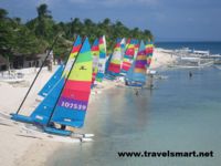
- (across the northernmost tip of Cebu). It was on Christmas day when the Spaniards reached the island. According to townfolks, it was supposed to be a special day of celebration but unfortunately a storm hit the island and so came the name “Malapacual”, Malas sa Pasko, which means “Unfortunate Christmas” in English. Malapascua is sometimes referred to as “Logon”, the main community in the south. “Logon” got its name when the Japanese and Americans fought over the island during WWII. The island is 3 km. long and 1 km. wide, with a population of about 3,000. It has white sand beaches and crystal clear waters. The west coast is ideal for swimming and snorkeling but one should be careful because of unpredictable weather. A walk or tour on the whole island can be done within half a day.
Articles
Find Philippine Travel Jobs in JobsCity.NET
Pages in category "Asia/Philippines/Cebu/Daanbantayan/Malapascua Island/"
The following 10 pages are in this category, out of 10 total.
A |
A cont. |
A cont. |


