
wiki.Alumni.NET - Your Location Information Resource
Image:Southern Taal Lake.jpg
From wiki.Alumni.NET
Size of this preview: 800 × 532 pixels
Full resolution (1,048 × 697 pixel, file size: 126 KB, MIME type: image/jpeg)
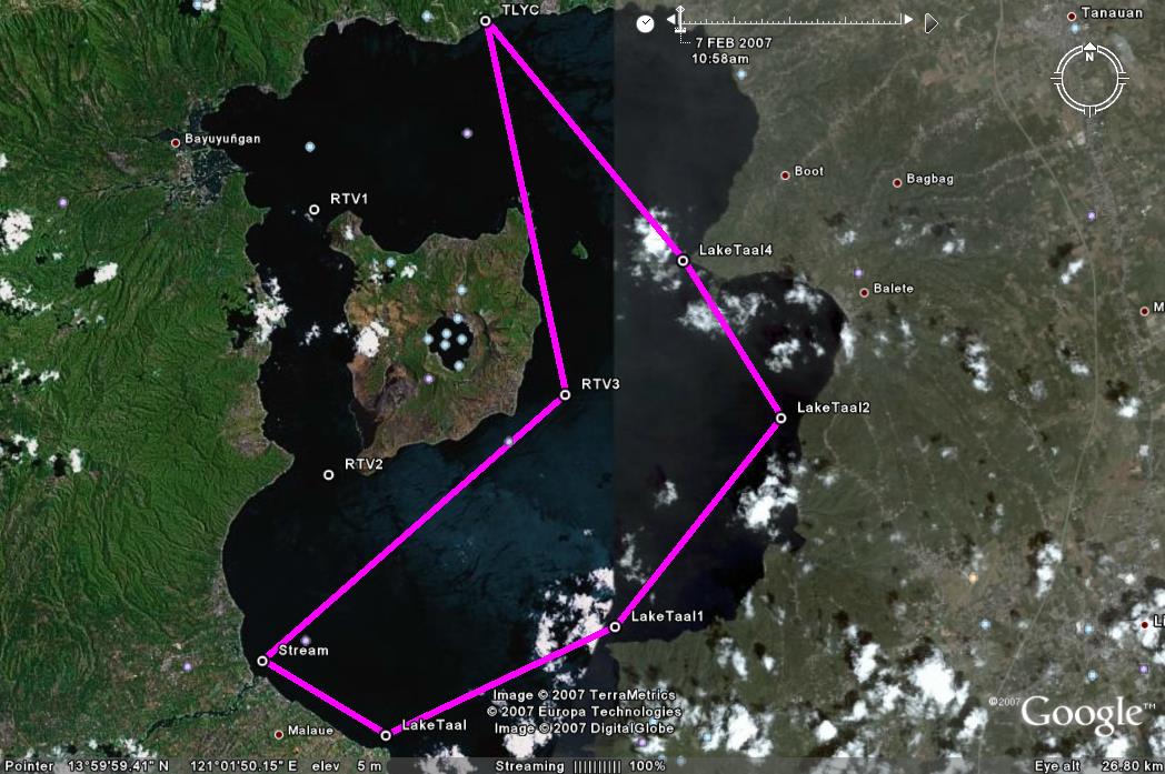
- Proposed route to visit the southern part of Taal Lake on Jan. 4, 2009.
- Leave TLYC 10am and head directly to the mouth of the Pansipit River. Find a spot there to have lunch. Perhaps there will be some volunteers to try to sail down the river. Pansipit is where the super yummy maliputo fish (talakitok) comes in from the sea.
- Proceed further south and then head upwind to the area where boats can park for Mt. Makulot (Lake Taal 1). There is a barrio called Lumampao on the base of Makulot and they have good halo-halo. What nice also is where the wake boarders go. But then again it's usually on the lee and it might take sometime getting out of. Excellent view of the West Wall though.
- Proceed to Lake Taal 2 and then pass through the Eastern island channel(Lake Taal 4). I heard this passage has electrical wires but is high enough for the hobies.
- Waypoints
- TLYC - N14 05.253 E121 00.394
- RTV3 - N13 59.898 E121 01.571
- Stream - N13 56.087 E120 57.105
 Mouth of Pansipit River
- Lake Taal - N13 55.018 E120 58.926
- Lake Taal1 - N13 56.579 E121 02.305
- Lake Taal2 - N13 59.563 E121 04.753
- Lake Taal4 - N14 01.819 E121 03.307

File history
Click on a date/time to view the file as it appeared at that time.
| Date/Time | Dimensions | User | Comment | |
|---|---|---|---|---|
| current | 12:34, 19 November 2007 | 1,048×697 (126 KB) | Tomacruz (Talk | contribs) | ( Proposed route to visit the southern part of Taal Lake on Jan. 6, 2008.) |
- Search for duplicate files
- Edit this file using an external application
See the setup instructions for more information.
Links
The following page links to this file:
